Self-guided itinerary · free
Ayder–Kavrun hiking itinerary: 2 days from Ayder to the Kavrun highlands
This is a hiking itinerary: the city, museum and valley stops of the 3-day Rize itinerary are not here. The base is Ayder; the main day is a long walk from Ayder at 1,350 m up to the Lower and Upper Kavrun highlands, reaching up to 2,350 m.
Prepared by: Kolay Seyahat content teamLast updated 23/10/2026Every fact links to an official source

This is not a package tour. This itinerary is free information. Flights, hotels and experiences are each sold separately, under their own seller’s terms, with separate payment and a separate contract. Prices are never linked to one another.
For this trip
Day by day
Progress is saved on this device only. Your location is never sent.
Itinerary map
Follow the stops day by day on the map; stops you mark as done turn green.
Map tiles come from OpenStreetMap servers. Your location is never read or sent anywhere; progress stays on this device.
Day 1 · Arrival in Ayder and Gelintülü Waterfall
Day 1: 1 stop is not in the route because the exact location is missing; open them one by one from the list below.
Day 2 · From Ayder to Lower and Upper Kavrun, then back to Ayder
Day 2: 1 stop is not in the route because the exact location is missing; open them one by one from the list below.
Stops without a map location (2)
These stops have no verified location yet, so they are not placed at a guessed spot. Google Maps searches them by name.
- Day 1 · 2 Ayder PlateauOpen in Google Maps
- Day 2 · 3 Back to Ayder the same wayOpen in Google Maps
Day 1 · Arrival in Ayder and Gelintülü Waterfall
Drive from Rize-Artvin Airport via Çamlıhemşin up to Ayder, settle in on the plateau and end the day with a short outing to Gelintülü Waterfall.
Day 1 · 1 · 09:00–12:30
From Rize-Artvin Airport to Ayder
The itinerary starts at Rize-Artvin Airport on the coast. The road from the airport to Rize city centre, then via Çamlıhemşin up to Ayder, climbs from the shoreline into the mountains. Along the way tea gardens give way to dense forest; after Çamlıhemşin the valley narrows and you reach the Ayder entrance gate of Kaçkar Mountains National Park. This first day is not a walking day: the aim is to reach Ayder before noon, settle in and start the next day’s long walk rested.
Getting there
Rize-Artvin Airport is 34 km from Rize city centre and 125 km from Artvin city centre; it is served by passenger shuttle, minibus, taxi, rental car and private car.
Source: dhmi.gov.tr · last checked 2026-10-23
Tips
Book a morning flight; reaching Ayder before noon makes the first day easier. Check the national park entry fee and the current road conditions before you set off.
Day 1 · 2 · 13:30–15:30
Ayder Plateau
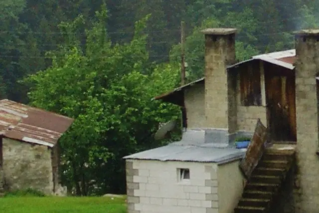
Ayder is a plateau in the Çamlıhemşin district, set among slopes covered with spruce and beech forest and facing the Kaçkar Mountains. According to the municipality, activities such as trekking, camping and photography take place here; it is the base of this itinerary and both nights are spent here. Spend the afternoon walking among the plateau’s wooden buildings, seeing where the next day starts and where the Kavrun road leaves the village. In the evening, an early dinner and an early night are the wisest preparation for day two’s long walk.
Good to know
Activities such as trekking, camping and photography take place on Ayder Plateau; according to the municipality, it can be visited at any time of year.
Source: camlihemsin.bel.tr · last checked 2026-10-23
Good to know
According to GoTürkiye, the water of the Ayder thermal springs is 55 degrees; the springs have been visited since Ottoman times.
Source: goturkiye.com · last checked 2026-10-23
Tips
Since you will leave early the next morning, prepare water, snacks and a rain jacket the evening before.
Day 1 · 3 · 15:30–17:30
Gelintülü Waterfall
The last stop of the day is Gelintülü Waterfall, just around Ayder. Named after its resemblance to a bridal veil, the waterfall, at more than 100 metres high, is one of the best-known natural sights of the plateau. Where the water meets the stream, the mountain view and the sound of the water are enough to end the day calmly after a long journey. A short outing to the waterfall also gives a gentle first taste of the next day’s altitude.
Good to know
Gelintülü Waterfall is more than 100 metres high; it takes its name from its resemblance to a bridal veil.
Source: goturkiye.com · last checked 2026-10-23
Tips
No official source details the path to the waterfall; ask locally for directions and return to Ayder before dark.

Day 2 · From Ayder to Lower and Upper Kavrun, then back to Ayder
Leave Ayder early in the morning, follow the Kavrun road on foot to Lower Kavrun and on to Upper Kavrun, then return to Ayder the same way. Shorter option: turn back at Lower Kavrun, about 17 km (according to OpenStreetMap data); the full day is about 23 km.
Day 2 · 1 · 07:00–10:30
From Ayder to Lower Kavrun
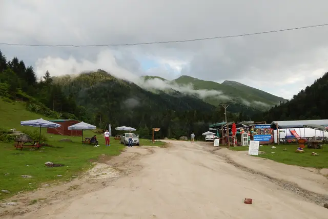
The longest part of the day is the walk to Lower Kavrun, starting early in the morning from Ayder. The way climbs through the forested slopes above Ayder and comes out onto open highland meadows where the trees thin out. Kavrun is one of the highland settlements inside Kaçkar Mountains National Park and has two parts; the first you reach is Lower Kavrun. In this section the walk follows a vehicle road; local vehicles may use it too, so keep to the side. Lower Kavrun is the natural turning point on a day when the weather breaks.
Good to know
Kavrun highland is divided into two parts, Lower Kavrun and Upper Kavrun, and lies 10 km from Ayder plateau.
Source: camlihemsin.bel.tr · last checked 2026-10-23
Good to know
There are 9 villages and 33 highland settlements in Kaçkar Mountains National Park.
Source: kulturportali.gov.tr · last checked 2026-10-23
Tips
Set off at 07:00; the risk of fog and rain rises in the afternoon. Assess the weather when you reach Lower Kavrun. This is a vehicle road; walk at the edge, where you can see vehicles and drivers can see you.
Day 2 · 2 · 10:30–13:00
Upper Kavrun
After Lower Kavrun the way climbs to the upper part of the highland, Upper Kavrun. Kavrun lies between 1,980 and 2,350 metres; considering that you left Ayder at 1,350 metres in the morning, by this point the day’s climb of about a thousand metres is behind you. Take a long break here, eat, drink and rest for the way back. Upper Kavrun is the highest and final point of this itinerary; the paths further up to the lakes and the summit count as high mountain hiking and are not part of it.
Good to know
Kavrun highland is 29 km from Çamlıhemşin town centre; it lies at a minimum of 1,980 and a maximum of 2,350 metres.
Source: camlihemsin.bel.tr · last checked 2026-10-23
Tips
Start back by 13:00 at the latest; keep the pace slow on the way down to spare your knees.
Day 2 · 3 · 13:00–17:00
Back to Ayder the same way
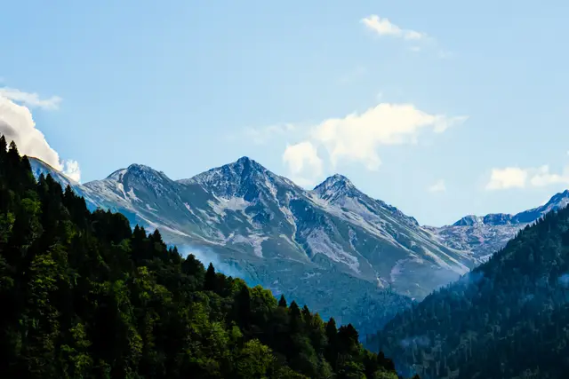
The way back reverses the morning route: from Upper Kavrun to Lower Kavrun, then down through the forested slopes to Ayder. Although the descent looks easier than the climb, tiredness at the end of a long day calls for care; shorten your steps and do not hesitate to take breaks. The Kaçkar Mountains also have marked trails suitable for summer walking; if you enjoyed this walk, the Kaçkar hiking itinerary on the Artvin side is a longer and higher option. Rest in Ayder in the evening; booking the return flight for the next morning keeps the day relaxed.
Good to know
The Kaçkar Mountains are suitable for nature walks in summer; walking activities take place on the national park’s 8 walking trails.
Source: kulturportali.gov.tr · last checked 2026-10-23
Tips
If the weather turns or you get tired, do not wait on the way; turn back from a point you passed in the morning.


Getting around
Getting there
The Ayder entrance gate of Kaçkar Mountains National Park is 17 km from Çamlıhemşin town centre and 84 km from Rize city centre.
Source: bolge12.tarimorman.gov.tr · last checked 2026-10-23
Entrance fee
In the 2026 tariff, Kaçkar Mountains National Park is in category I of the Black Sea-2 group in Artvin and Rize; the category I entry fee per person in this group is TRY 65.
Source: tarimorman.gov.tr · last checked 2026-10-23
Entrance fee
Anyone found to have entered a national park without paying the entry fee is fined four times the fee (law of 19 March 2026).
Source: tarimorman.gov.tr · last checked 2026-10-23
Good to know
In national parks, noisy activities that disturb the environment or other visitors and loud music are not allowed; visitors use these areas within the rules set by the park administration.
Source: tarimorman.gov.tr · last checked 2026-10-23
Good to know
All emergency numbers have been merged into 112; calls to 112 from mobile and landlines are free and the caller’s location is detected automatically.
Source: icisleri.gov.tr · last checked 2026-10-23
What and where to eat
What to eat and where to look
Cornbread and muhlama
In Ayder, at breakfast
Source: goturkiye.com · last checked 2026-10-23
Local specialities
Rize muhlama
Registered with an indication of source on behalf of the Rize Chamber of Commerce and Industry (registration no 704, 2021).
Source: TÜRKPATENT Coğrafi İşaret · Geographical indication (reg. no 704) · last checked 2026-10-23
Ayder honey
Registered as a designation of origin on behalf of the Ayder Kaplıca and Aşağı Şimşirli Agricultural Development Cooperative (registration no 1081, 2022).
Source: TÜRKPATENT Coğrafi İşaret · Geographical indication · designation of origin (reg. no 1081) · last checked 2026-10-23
Opening hours and prices vary by venue; check the venue’s own site before you go. Recommendations are not paid placements.
Where to stay
Candidates were picked by distance to the area, star rating, guest rating (weighted by number of reviews) and completeness of hotel details. Ratings, review counts and details come live from our catalogue. Tiers follow the star rating.
Sample dates: 23.11–24.11 (1 night), 2 adults. Prices change with dates; choose your own dates on the hotel page.
Ayder
The plateau where the walk starts and ends; spending both nights here lets day two start early.
Good for: The whole itinerary
Budget


Çamlıhemşin
17 km from the Ayder entrance gate; for those who cannot find a room in Ayder.
Good for: Those who cannot find a room in Ayder

Photos: Pexels (Daha Uzaga, Yeşim Çolak) · Wikimedia (Dr. Zeynel Cebeci, Sinan Şahin)
Image credits
- A traditional highland house on Ayder Plateau with stone walls, two chimneys and a wooden balcony — Dr. Zeynel Cebeci · CC BY-SA 3.0 · Wikimedia
- The Kavrun road between forested slopes on a cloudy day — Sinan Şahin · CC BY 3.0 · Wikimedia
